|
|
Toolbar:
Menu: CAD-Earth > Mesh commands > Annotate cross sections.
|
|
|
Command line: CE_ANNOTSECT
Prompts:
Select cross section: Insertion point (ENTER to exit):
CAD-Earth version: Plus, Premium. |
Command description:
After cross section drawings are generated from a mesh, you can place additional elevation-offset annotations in a selected cross section by specifying insertion points. Elevation and offset values will be calculated according to the scale and rotation of the selected cross section block.
.png)
Cross section annotation dialog box.
Dialog box settings:
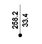
ØStacked annotations (elevation over offset). Horizontally oriented annotations will be created placing offset annotations directly below elevation annotations. If this option is not checked, vertically oriented annotations will be created, placing elevation annotations to the left of a vertical leader line and offset annotations to the right.
|
Stacked annotation |
vertical annotation |
.gif)
ØText.
•Elevation prefix. Text will be added before each elevation annotation.
•Elevation suffix. Text will be appended to the end of each elevation annotation.
•Offset prefix. Text will be added before each offset annotation.
•Offset suffix. Text will be appended to the end each offset annotation.
•Text size. Height for elevation and offset annotations.
•Decimal places. Number of digits displayed to the right of the decimal point for elevation and offset annotations.
•Text color. The selected color will be used for elevation and offset annotations.
•Text layer. Elevation and offset annotations will be created in the layer selected.
•Text style. The selected text style will be used for elevation and offset annotations.
Tips:
•You must select an existing cross section drawing created with the corresponding CAD-Earth command before an annotation can be placed.
•You can specify a fractional text size (1/8, 3/8, etc.) and the value will be automatically converted to a decimal value.
Related topics:
•Draw cross sections from mesh
•Import terrain mesh from Google Earth
Copyright © 2021 Arqcom Software
Google Earth© is a registered trademark of Google inc. All other trademarks are the property of their respective owners.